BEDFORD, NS / ACCESSWIRE / February 5, 2021 / (TSXV:SSE) – Silver Spruce Resources, Inc. (“Silver Spruce” or the “Company”) is pleased to announce another step forward in its ongoing exploration programs on the El Mezquite and Jackie properties with the signing of an airborne survey contract with Eagle Mapping Ltd. (“Eagle Mapping”) of Port Coquitlam, British Columbia.
“Silver Spruce is adding to its growing digital database for the El Mezquite and Jackie exploration properties while advancing our active Phase 1 mapping and sampling programs. The new LiDAR data will enhance 2D and 3D spatial interpretation of the historical and current geological and structural information to support initial drill program design at El Mezquite”, said Greg Davison, Silver Spruce VP Exploration. “Our early prospecting reports from Jackie (see image below) point to a similar alteration style to El Mezquite and we are identifying pristine targets for planned Phase 2 detailed mapping studies upon receipt of analytical data from ALS Global”.
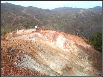
Early stage prospecting at Jackie showing extensive silicification, argillic and oxide alteration
The Company has retained Eagle Mapping Ltd. (“Eagle Mapping”) to carry out a LiDAR (Light Detection and Ranging) survey over the El Mezquite and Jackie properties. Eagle Mapping will collect LiDAR data and aerial photography at a minimum density of 8 ppm with expected accuracies of ±15 cm in the vertical and ±30 cm in the horizontal. Colour aerial photography will be orthorectified to the LiDAR base earth model with a 12 cm pixel resolution. Digital elevation (DEM) and digital surface models (DSM) with contours at 1 metre will be generated. The LASer (LAS) point cloud with classified bare earth and metadata final report will be contained in the deliverables. The LAS format is an open binary file format designed for the interchange and archiving of LiDAR point cloud data and regarded as an industry standard for LiDAR data.
The Eagle Mapping aircraft will mobilize from Abbotsford, British Columbia upon receipt of all international flight permits. The survey flights will be based from Yuma, Arizona and should be completed by mid-February 2021.
Eagle Mapping has more than 30 years of Aerial Mapping experience and flown LiDAR surveys from Alaska to Chile for clients associated with Mining, Forestry, Engineering, Ecological and First Nations sectors. They specialize in Aerial LiDAR and air photo collection and processing, and own state of the art LiDAR collection equipment including the RIEGL VQ-780i, LMS-Q1560 and LMS-Q780 using the most sophisticated software to process LiDAR data.
GeoDigital Imaging de Mexico S.A. de C.V. (“GeoDigital”) has been retained to compile the Company’s El Mezquite and Jackie GIS data and prepare digital base maps for geographical, geological, geochemical and geophysical information including the upcoming LiDAR data.
GeoDigital, based in Hermosillo since 2008, provides the highest international quality standards in geological consulting, satellite imagery and geographic information systems, resource estimation and 3D modelling, topography and digital elevation models, geology and software training.
Exploration Update
Exploration at the El Mezquite property has identified historical artisanal mining, multiple zones of brecciation, silicification and silicate-oxide-sulphate-clay alteration, coincident high chargeability anomalies, and discrete geochemical and structural trends, containing broad areas of elevated precious metal values. The Company’s prospecting team has completed two field stints of two weeks duration each on the property with the completion of the planned six week Phase 1 program expected in late February (Press release August 12, 2020). The initial exploration sample data and geochemical analyses are being compiled for interpretation and will be provided shortly.
The Jackie property, located 2 km to the southeast along the general geological strike of the belt, has seen very little, if any, structured exploration. Early prospecting summary reports show areas of intense alteration and brecciation similar to those observed at El Mezquite. The Company’s prospecting team has been active on the property for more than three weeks of the planned one-month Phase 1 program to mid-February (Press release January 18, 2021) and initial exploration results will be provided when available.
Project Geology and Location
Silver Spruce’s El Mezquite and Jackie Projects are located within the western portion of the Sierra Madre Occidental Volcanic Complex within the prominent northwest-trending “Sonora Gold Belt” of northern Mexico and parallel to the precious metals-rich Mojave-Sonora Megashear.
The 180-ha El Mezquite Au property, a drill-ready project, and the 1,130-ha Jackie Au-Ag property, an early-stage project, both are located approximately 175 km east-southeast of Hermosillo, Sonora, Mexico. The Properties are situated only two kilometres apart in the N-S direction and approximately six kilometres northwest of the Nicho deposit currently under mine development by Minera Alamos.
Other nearby large operating mines include Alamos Gold’s Los Mulatos gold mine and Agnico Eagle’s La India gold mine located 50-60 km to the northeast, Agnico Eagle’s Pinos Altos Mine, 95 km southeast and Argonaut’s La Colorada Mine, 100 km to the west.
Exploration is very active, with adjacent and nearby properties reported to be held by Minera Alamos, Newmont, Garibaldi, Evrim, Kootenay Silver and Peñoles.
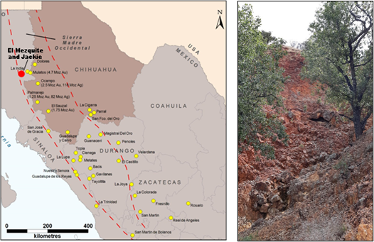
Left – Map of the Sierra Madre Occidental with property locations
Right – Silicification and hematite overprint at the El Mezquite property
The known mineralization commonly consists of disseminated gold hosted in strongly argillized and moderately silicified andesite rocks, typical to the Sierra Madre geological model of the principal deposits. There are at least four hydrothermally altered, oxidized zones at El Mezquite (see image above) trending north to northwest though the major trend of mineralization identified by previous rock sampling has been reported as NE-SW. The highest values of gold and silver reported on El Mezquite are 3.41 g/t Au and 198 g/t Ag. No historical data has been recovered for the Jackie property.
Qualified Person
Greg Davison, PGeo (BC), Vice-President Exploration & Director, is the Company’s internal Qualified Person (QP) and is responsible for the technical content of this press release within the meaning of National Instrument 43-101 Standards of Disclosure for Mineral Projects (“NI 43-101”), under TSX guidelines.
About Silver Spruce Resources Inc.
Silver Spruce Resources Inc. is a Canadian junior exploration company which has signed Definitive Agreements to acquire 100% of the Melchett Lake Zn-Au-Ag project in northern Ontario, and with Colibri Resource Corp. in Sonora, Mexico, to acquire 50% interest in Yaque Minerales S.A de C.V. holding the El Mezquite Au project, a drill-ready precious metal project, and 50% interest in Colibri’s early stage Jackie Au project, with both properties located <10 kilometres west from Minera Alamos’s Nicho deposit. The Company also is pursuing exploration of the drill-ready and fully permitted Pino de Plata Ag project, located 15 kilometres west of Coeur Mining’s Palmarejo Mine, in western Chihuahua, Mexico. Silver Spruce Resources Inc. continues to investigate opportunities that Management has identified or that have been presented to the Company for consideration.
Contact:
Silver Spruce Resources Inc.
Brian Penney, Chairman and CEO
(902) 430-8270
info@silverspruceresources.com www.silverspruceresources.com
Neither TSX Venture Exchange nor its Regulation Services Provider (as that term is defined in the policies of the TSX Venture Exchange) accepts responsibility for the adequacy or accuracy of this release.
Notice Regarding Forward-Looking Statements
This news release contains “forward-looking statements,” Statements in this press release which are not purely historical are forward-looking statements and include any statements regarding beliefs, plans, expectations or intentions regarding the future, including but not limited to, statements regarding the private placement.
Actual results could differ from those projected in any forward-looking statements due to numerous factors. Such factors include, among others, the inherent uncertainties associated with mineral exploration and difficulties associated with obtaining financing on acceptable terms. We are not in control of metals prices and these could vary to make development uneconomic. These forward-looking statements are made as of the date of this news release, and we assume no obligation to update the forward-looking statements, or to update the reasons why actual results could differ from those projected in the forward-looking statements. Although we believe that the beliefs, plans, expectations and intentions contained in this press release are reasonable, there can be no assurance that such beliefs, plans, expectations or intentions will prove to be accurate.
SOURCE: Silver Spruce Resources Inc.


