Vancouver, British Columbia–(Newsfile Corp. – February 7, 2024) – First Majestic Silver Corp. (NYSE: AG) (TSX: FR) (FSE: FMV) (the “Company” or “First Majestic”) is pleased to announce positive drilling results from its 2023 exploration programs at San Dimas, Santa Elena, and Jerritt Canyon. The drilling programs were designed to test new silver and gold mineral targets, increase Mineral Resources and convert Mineral Resources to Mineral Reserves.
“We are very encouraged with the exploration results that have been achieved throughout 2023,” stated Keith Neumeyer, President & CEO of First Majestic. “The recent drilling has accomplished multiple goals from highlighting new geologically prospective areas to expanding and further defining known silver and gold mineralization. These results provide the basis for First Majestic’s year-end update of Mineral Resource and Mineral Reserve estimates expected to be released at the end of March. At San Dimas, we have tested previously undrilled veins like the Peggy vein and have explored extensions of known mineralization such as the Perez, Santa Teresa and Rosario veins. At Santa Elena, infill drilling of the Ermitaño vein intersected mineralization that is in many cases better than expected while follow up drilling of the new Javelin target at Jerritt Canyon has identified what appears to be a new gold mineralized zone near underground infrastructure and continues to highlight the exploration potential of the asset. These results set us up well for an exciting start for 2024.”
DRILLING HIGHLIGHTS
Select highlights from the Company’s ongoing exploration programs include the following drill hole intercepts:
San Dimas Highlights (true width)
- Hole ST23_014: 40.40 g/t Au and 2,092 g/t Ag over 0.91 metres (“m”);
- Hole SIN23_073: 11.53 g/t Au and 758 g/t Ag over 2.97m;
- Hole PE23_225: 3.78 g/t Au and 421 g/t Ag over 7.78m;
- Hole PE23_242: 7.36 g/t Au and 1,238 g/t Ag over 2.41m;
Santa Elena Highlights (true width)
- Hole EWUG-23-012: 20.95 g/t Au & 311 g/t Ag over 4.88m;
- Hole EWUG-23-007: 18.50 g/t Au & 304 g/t Ag over 1.71m;
- Hole EWUG-23-015: 9.38 g/t Au & 230 g/t Ag over 5.23m;
Jerritt Canyon Highlights (apparent width)
- Hole SSX-235020: 12.04 g/t Au over 25.9m
- Hole SMI-230011: 8.76 g/t Au over 15.2m
- Hole SMI-230013: 7.44 g/t Au over 15.7m
SAN DIMAS EXPLORATION RESULTS
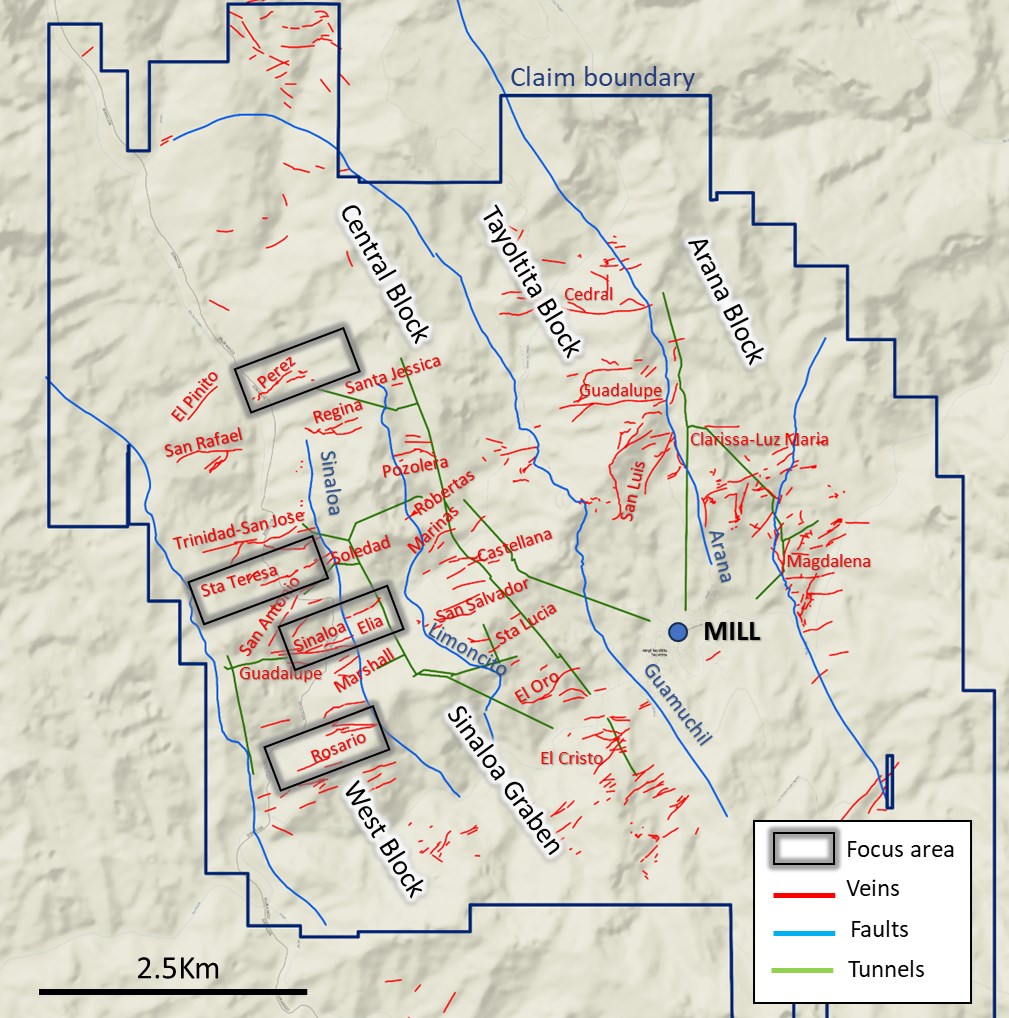
Exploration drill holes at the San Dimas property intersected significant gold and silver mineralization in multiple veins. Four areas are highlighted here: Sinaloa North-Elia, Santa Teresa, Rosario and Perez (Figure 1).
To view an enhanced version of this graphic, please visit:
https://images.newsfilecorp.com/files/1475/197046_8902b3aa14ef3a05_002full.jpg
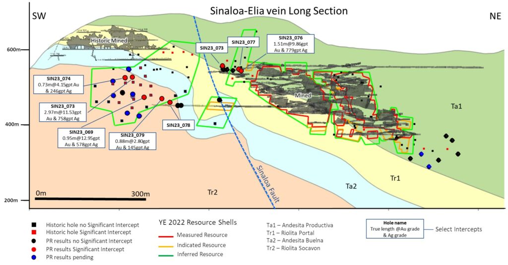
Drilling at the historic Sinaloa North-Elia mines/veins cut multiple gold and silver mineralized vein intercepts. The drilling confirmed and further delineates the presence of mineralization below historic mining of the Sinaloa vein (Figure 2). Select drill hole assay grade and intervals (true width) of the Sinaloa vein intersections are shown below:
- Hole SIN23_073: 11.53 g/t Au & 758 g/t Ag over 2.97m;
- Hole SIN23_076: 9.86 g/t Au & 779 g/t Ag over 1.51m;
- Hole SIN23_069: 12.65 g/t Au & 578 g/t Ag over 0.95m;
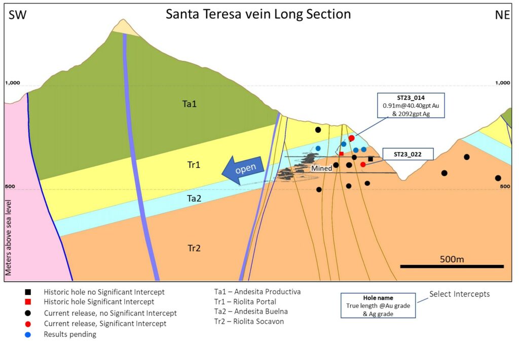
Expansionary drilling on the projection of the historic Santa Teresa vein has returned significant intercepts. The vein remains undrilled to the west for ~500m along strike for exploration upside (Figure 3). Drill hole assay grade and intervals (true width) of the vein intersections are shown below:
- Hole ST23_014
- 3.95 g/t Au & 270 g/t Ag over 1.86m;
- 2.07 g/t Au & 130 g/t Ag over 2.90m;
- 40.40 g/t Au & 2,092 g/t Ag over 0.91m;
- Hole ST23_022
- 3.19 g/t Au & 274 g/t Ag over 0.78m;
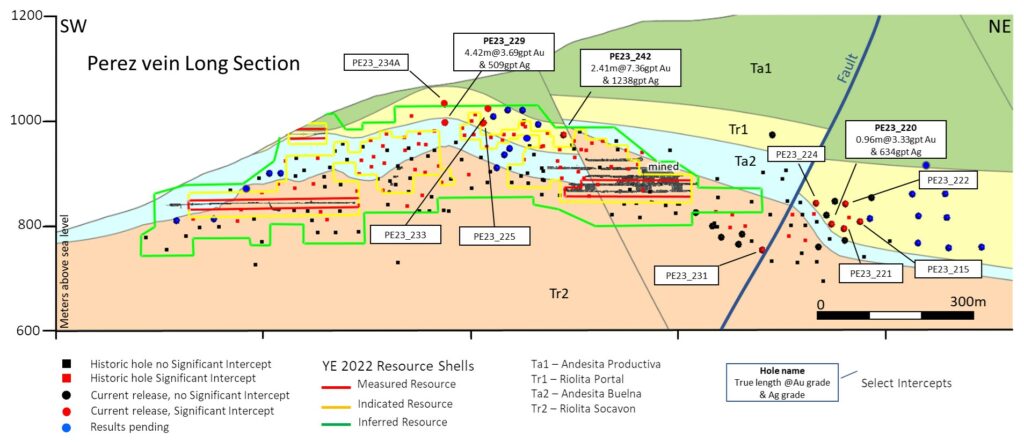
Drilling at the Perez vein delineated and extended gold and silver mineralization up-dip on one of the known ore shoots and further defined a newly identified mineralized shoot to the east. In some cases, drilling cut unmodeled gold and silver mineralization in secondary veins, breccias and stockworks in the hanging and foot wall of the primary vein for higher ore tonnage. The Perez vein exploration potential remains open to the east where it projects into an area where post-mineral faulting is anticipated to decrease, providing confirmation of ore body continuity (Figure 4). Select drill hole assay grade and intervals (true width) of the vein intersections are shown below:
- Hole PE23_225: 3.78 g/t Au & 421 g/t Ag over 7.78m;
- Hole PE23_242: 7.36g/t Au & 1,238 g/t Ag over 2.41m;
- Hole PE23-229: 3.69 g/t Au & 509 g/t Ag over 4.42m;
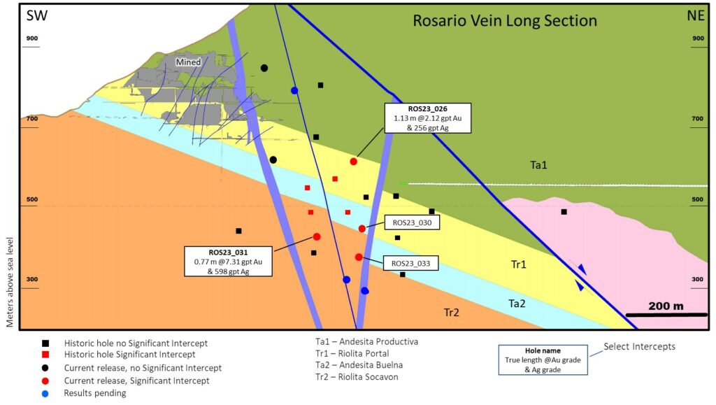
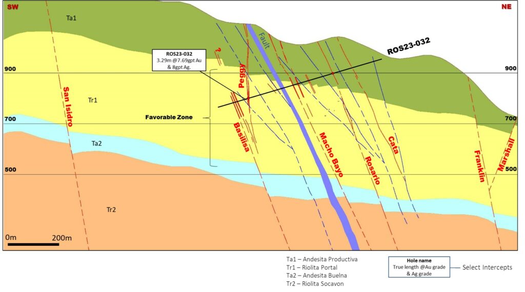
Drilling at the Rosario vein continues to delineate a mineralized volume east of the historic mining area (Figure 5). Drill testing also cut multiple veins in the footwall of Rosario: the Macho Bayo, Peggy and Basilisa veins. The intersection of the Peggy vein returned significant gold and silver values over 3m, the newly discovered mineralization is open in all directions (Figure 6). Select drill hole assay grade and intervals (true width) are shown below:
- Hole RO23_031: 7.31g/t Au & 598 g/t Ag, 0.77 m;
- Hole RO23_032: 7.69 g/t Au & 8g/t Ag, 3.29 m (Peggy vein)
To view an enhanced version of this graphic, please visit:
https://images.newsfilecorp.com/files/1475/197046_8902b3aa14ef3a05_003full.jpg
To view an enhanced version of this graphic, please visit:
https://images.newsfilecorp.com/files/1475/197046_8902b3aa14ef3a05_004full.jpg
To view an enhanced version of this graphic, please visit:
https://images.newsfilecorp.com/files/1475/197046_8902b3aa14ef3a05_005full.jpg
To view an enhanced version of this graphic, please visit:
https://images.newsfilecorp.com/files/1475/197046_8902b3aa14ef3a05_006full.jpg
To view an enhanced version of this graphic, please visit:
https://images.newsfilecorp.com/files/1475/197046_8902b3aa14ef3a05_007full.jpg
SANTA ELENA EXPLORATION RESULTS
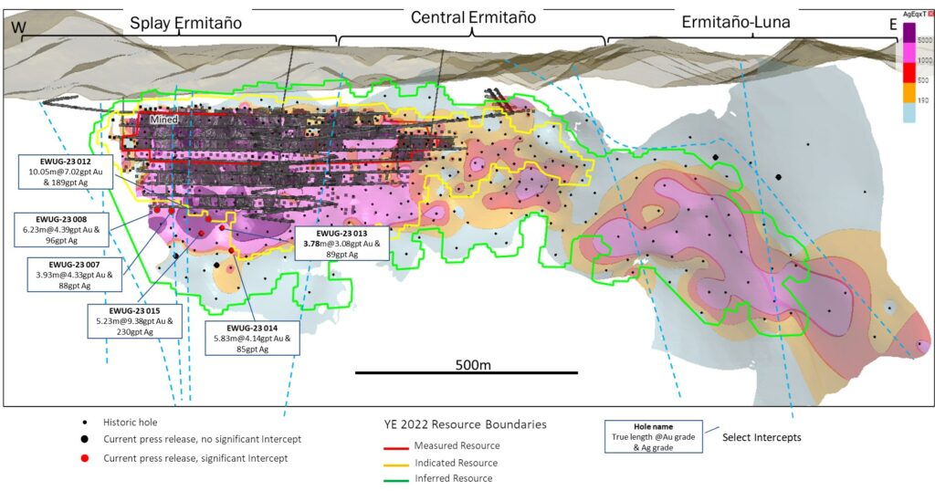
An infill drilling program designed to convert Mineral Resources to Mineral Reserves at the Ermitaño mine, cut multiple high-grade intersections of gold and silver mineralization (Figure 7). In addition to intercepts of the Ermitaño vein, multiple holes intersected mineralization in secondary veins and breccia zones located in the hanging and footwall of the Ermitaño vein proper. Select drill hole assay grade and true width from the intersections include:
- Hole EWUG-23-012: 20.95 g/t Au & 311 g/t Ag over 4.88m;
- Hole EWUG-23-007: 18.50 g/t Au & 304 g/t Ag over 1.71m;
- Hole EWUG-23-015: 9.38 g/t Au & 230 g/t Ag over 5.23m;
To view an enhanced version of this graphic, please visit:
https://images.newsfilecorp.com/files/1475/197046_8902b3aa14ef3a05_008full.jpg
JERRITT CANYON EXPLORATION RESULTS
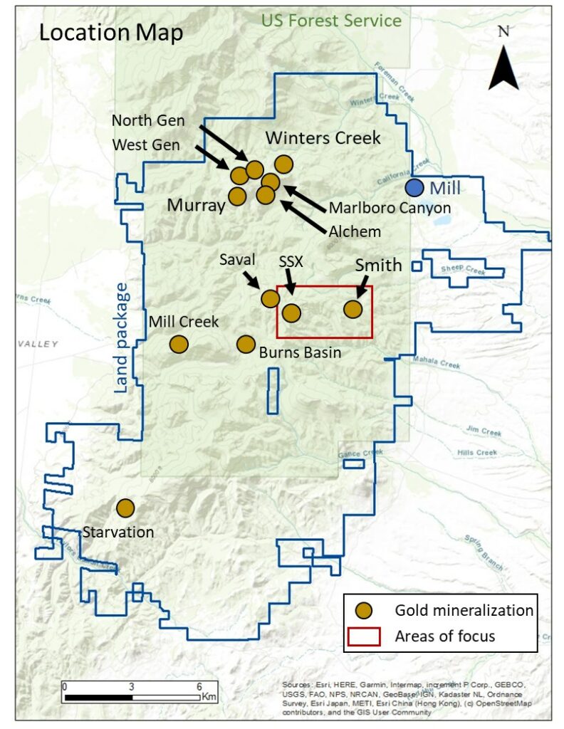
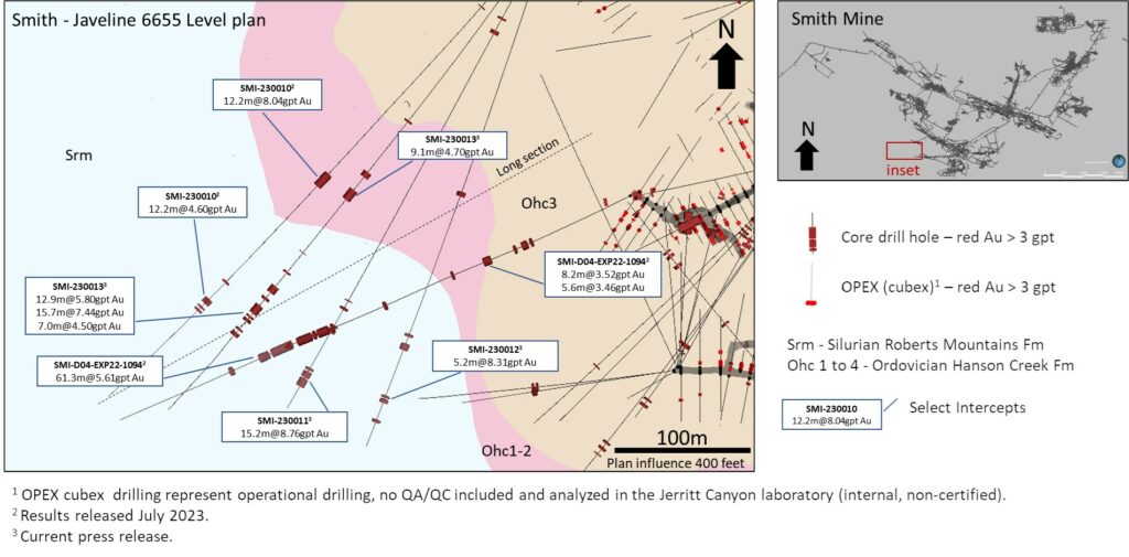
Drilling at Jerritt Canyon has returned positive results located within the SSX and Smith mine areas (Figure 8).
To view an enhanced version of this graphic, please visit:
https://images.newsfilecorp.com/files/1475/197046_8902b3aa14ef3a05_009full.jpg
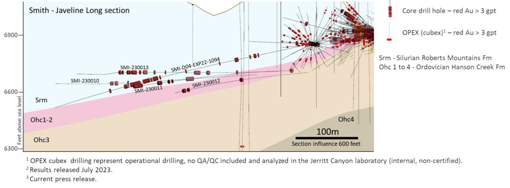
Drilling designed to expand the Javelin target identified in July 2023 cut multiple significant gold intersections located between 90m and 340m from existing Smith mine developments. The flat-lying geometry of the gold mineralization trends at a relatively low angle to the drill hole intersections which define a mineralized volume that remains open in multiple directions (Figure 9 and Figure 10).
- Hole SMI-230011:
- 4.34 g/t Au over 6.1m;
- 8.76 g/t Au over 15.2m;
- Hole SMI-230012:
- 8.31 g/t Au over 5.2m;
- Hole SMI-230013:
- 4.70 g/t Au over 9.1m;
- 5.80 g/t Au over 12.9m;
- 7.44 g/t Au over 15.7m;
- 4.50 g/t Au over 7.0m;
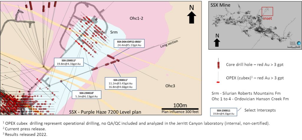
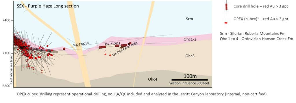
Drilling of the Purple Haze exploration target intersected new gold mineralization located up to 100m away from existing developments of the SSX mine. The geometry and controls of the gold mineralization are interpreted to trend at a relatively low angle to the drill hole intersections as shown in Figure 11 and Figure 12. Mineralization remains open in multiple directions.
- Hole SSX-230010:
- 6.13 g/t Au over 5.3m;
- Hole SSX-230011:
- 4.33 g/t Au over 19.8m;
- 3.47 g/t Au over 11.2m;
- 4.60 g/t Au over 16.8m;
- Hole SSX-230013:
- 8.97 g/t Au over 6.1m;
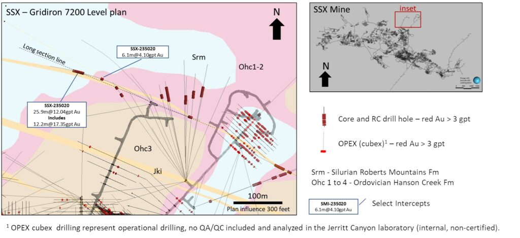
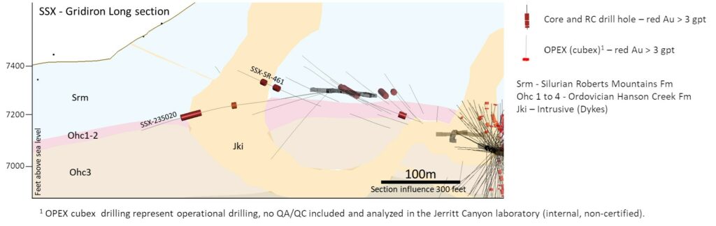
Exploration drilling designed to test prospective geologic features in the Gridiron target cut two significant gold intercepts located approximately 80 and 120m away from existing SSX mine development. The mineralization is hosted adjacent to a Jurassic dike cutting the base of the Silurian Roberts Mountain Formation. The geometry of the gold mineralization is not yet defined, and the mineralization is open in several directions (Figure 13 and Figure 14).
- Hole SSX-235020:
- 4.1m g/t Au over 6.1m;
- 12.04 g/t Au over 25.9m;
To view an enhanced version of this graphic, please visit:
https://images.newsfilecorp.com/files/1475/197046_8902b3aa14ef3a05_010full.jpg
To view an enhanced version of this graphic, please visit:
https://images.newsfilecorp.com/files/1475/197046_8902b3aa14ef3a05_011full.jpg
To view an enhanced version of this graphic, please visit:
https://images.newsfilecorp.com/files/1475/197046_8902b3aa14ef3a05_012full.jpg
To view an enhanced version of this graphic, please visit:
https://images.newsfilecorp.com/files/1475/197046_8902b3aa14ef3a05_013full.jpg
To view an enhanced version of this graphic, please visit:
https://images.newsfilecorp.com/files/1475/197046_8902b3aa14ef3a05_014full.jpg
To view an enhanced version of this graphic, please visit:
https://images.newsfilecorp.com/files/1475/197046_8902b3aa14ef3a05_015full.jpg
Table 1: Summary of Significant Silver and Gold Drill Hole Intercepts at San Dimas.
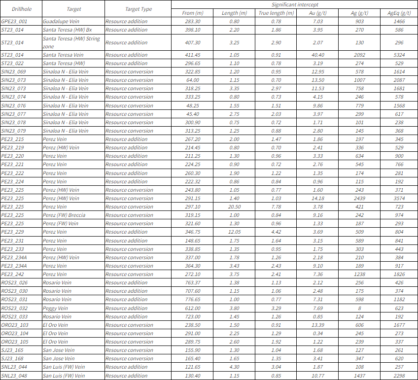
Note: All holes are Diamond Drill; AgEq grade = silver grade (g/t) + [gold grade (g/t)*80]
From, To and Length indicated in metres, true width of the intercept is calculated per drill hole and vein angles.
Gold and silver drill hole intercepts at San Dimas were composited using the length weighted averages of uncapped sample assays, a 190 g/t AgEq minimum grade, and a minimum composite length of 0.7m (true width). A maximum 1m below the minimum grade was allowed as internal dilution and a single sample below the minimum but above 100 g/t AgEq was allowed in the hanging or footwall to achieve minimum true width in select cases. True width of intercepts is calculated based on current understanding of drillhole and vein angle geometry.
Table 2: Summary of Significant Drill Hole Silver and Gold Intercepts at Santa Elena.
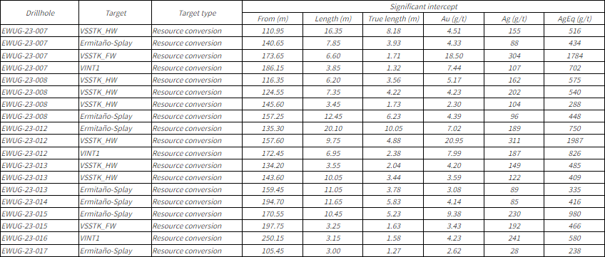
Note: All holes are Diamond Drill; AgEq grade = silver grade (g/t) + (gold grade (g/t)*80)
From, To and Length indicated in metres, true width of the intercept is calculated per drill hole and vein angles.
Gold and silver drill hole intercepts at Santa Elena were composited using the length weighted averages of uncapped sample assays, a 190 g/t AgEq minimum grade, and a minimum length of 1m (true width). A maximum 1m below the minimum grade was allowed as internal dilution. True width of intercepts is calculated based on current understanding of drillhole and vein angle geometry.
Table 3: Summary of Significant Drill Hole Gold Intercepts at Jerritt Canyon.
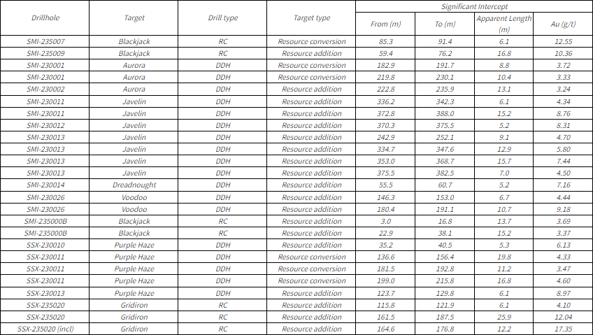
Note From, To and Length indicated in metres, true thickness of the mineralized zones are unknown at this time. Results >15gpt Au are reported as “includes”.
Gold drill hole intercepts at Jerritt Canyon were composited using the length weighted averages of uncapped sample assays, a 3.0 g/t Au minimum grade, and a minimum composite length of 5m. A maximum 5m below the minimum grade was allowed as internal composite dilution. True thickness of intercepts is not known at this time.
QUALITY ASSURANCE AND QUALITY CONTROL
First Majestic’s drilling programs follow industry standard established QA/QC insertion protocols with standards, blanks and duplicates introduced into the San Dimas, Santa Elena and Jerritt Canyon sample-stream. After geological logging, all drill core samples are cut in half. One half of the core is submitted to the designated laboratory for analysis and the remaining half of the core is retained on-site for verification and reference purposes.
Core samples from Jerritt Canyon drilling were submitted to First Majestic’s Central Laboratory (“Central Lab”) (ISO 9001-2015). Core samples from San Dimas and Santa Elena drilling were submitted to the Central Laboratory or SGS in Durango, Mexico (“SGS”) (ISO/IEC 17025:2017)
At the Central Lab, gold is analyzed by fire assay with atomic absorption finish (Au-AA13, ASAG-13-Au). Results above 10 g/t Au are analyzed by 20 g Fire Assay gravimetric finish (ASAG-14). Silver is analyzed by 3-Acid Digest AAS finish (AAG-13) or by 20 g Fire Assay Gravimetric Finish (ASAG-13-Ag). Results above 200 g/t Ag are analyzed by 20 g Fire Assay gravimetric finish (ASAG-14). At SGS, gold is analyzed by 30 g Fire Assay AAS finish (GE_FAA30V5). Results above 10 g/t Au are analyzed by 30 g Fire Assay gravimetric Finish (GO_FAG30V). Silver is analyzed by 2 g 3-Acid digest AAS finish (GE_AAS33E50). Results above 100 g/t Ag are analyzed by 30 g Fire Assay Gravimetric Finish (GO_FAG37V).
See the Company’s most recently filed Annual Information Form, available at www.sedarplus.ca, for further information concerning QA/QC and data verification matters, the key assumptions, parameters and methods used by the Company to estimate Mineral Reserves and Mineral Resources, and for a detailed description of known legal, political, environmental, and other risks that could materially affect the Company’s business and the potential development of the Company’s Mineral Reserves and Mineral Resources.
QUALIFIED PERSON
Gonzalo Mercado, P. Geo., the Company’s Vice President of Exploration and Technical Services and a “Qualified Person” as defined under National Instrument 43-101 Standards of Disclosure for Mineral Projects (“NI 43-101”), has reviewed and approved the scientific and technical information contained in this news release. Mr. Mercado has verified the exploration data contained in this news release, including the sampling, analytical and test data underlying such information.
ABOUT THE COMPANY
First Majestic is a publicly traded mining company focused on silver and gold production in Mexico and the United States. The Company presently owns and operates the San Dimas Silver/Gold Mine, the Santa Elena Silver/Gold Mine and the La Encantada Silver Mine as well as a portfolio of development and exploration assets, including the Jerritt Canyon Gold project located in northeastern Nevada, U.S.A.
First Majestic is proud to offer a portion of its silver production for sale to the public. Bars, ingots, coins and medallions are available for purchase online at its Bullion Store at some of the lowest premiums available. In Q1 2024, First Majestic will also commence bullion production from its 100%-owned and operated minting facility, First Mint, LLC, to manufacture its very own exceptional silver bullion products catering to the growing demand for physical silver.
For further information, contact info@firstmajestic.com, visit our website at www.firstmajestic.com or call our toll-free number 1.866.529.2807.
FIRST MAJESTIC SILVER CORP.
“signed”
Keith Neumeyer, President & CEO
Cautionary Note Regarding Forward-Looking Statements
This news release contains “forward‐looking information” and “forward-looking statements” under applicable Canadian and U.S. securities laws (collectively, “forward‐looking statements”). These statements relate to future events or the Company’s future performance, business prospects or opportunities that are based on forecasts of future results, estimates of amounts not yet determinable and assumptions of management made in light of management’s experience and perception of historical trends. Assumptions may prove to be incorrect and actual results and future events may differ materially from those anticipated. Statements such as the timing of the Company’s year-end update of Mineral Resource and Mineral Reserve estimates are forward-looking statements. Statements concerning Proven and Probable Mineral Reserves and Mineral Resource estimates may also be deemed to constitute forward‐looking statements to the extent that they involve estimates of the mineralization that will be encountered as and if the property is developed, and in the case of Measured and Indicated Mineral Resources or Proven and Probable Mineral Reserves, such statements reflect the conclusion based on certain assumptions that the mineral deposit can be economically exploited. Any statements that express or involve discussions with respect to predictions, expectations, beliefs, plans, projections, objectives or future events or performance (often, but not always, using words or phrases such as “seek”, “anticipate”, “plan”, “continue”, “estimate”, “expect”, “may”, “will”, “project”, “predict”, “forecast”, “potential”, “target”, “intend”, “could”, “might”, “should”, “believe” and similar expressions) are not statements of historical fact and may be “forward‐looking statements”.
Actual results may vary from forward-looking statements. Forward-looking statements are subject to known and unknown risks, uncertainties and other factors that may cause actual results to materially differ from those expressed or implied by such forward-looking statements, including but not limited to: material adverse changes, unexpected changes in laws, rules or regulations, or their enforcement by applicable authorities; the failure of parties to contracts with the company to perform as agreed; social or labour unrest; changes in commodity prices; and the failure of exploration programs or studies to deliver anticipated results or results that would justify and support continued exploration, studies, development or operations. Although the Company has attempted to identify important factors that could cause actual results to differ materially from those contained in forward-looking statements, there may be other factors that cause results not to be as anticipated, estimated or intended.
The Company believes that the expectations reflected in these forward‐looking statements are reasonable, but no assurance can be given that these expectations will prove to be correct and such forward‐looking statements included herein should not be unduly relied upon. These statements speak only as of the date hereof. The Company does not intend, and does not assume any obligation, to update these forward-looking statements, except as required by applicable laws.
Cautionary Note to United States Investors
The Company is a “foreign private issuer” as defined in Rule 3b-4 under the United States Securities Exchange Act of 1934, as amended, and is eligible to rely upon the Canada-U.S. Multi-Jurisdictional Disclosure System, and is therefore permitted to prepare the technical information contained herein in accordance with the requirements of the securities laws in effect in Canada, which differ from the requirements of the securities laws currently in effect in the United States. Accordingly, information concerning mineral deposits set forth herein may not be comparable with information made public by companies that report in accordance with U.S. standards.
Technical disclosure contained in this news release has not been prepared in accordance with the requirements of United States securities laws and uses terms that comply with reporting standards in Canada with certain estimates prepared in accordance with NI 43-101.
NI 43-101 is a rule developed by the Canadian Securities Administrators that establishes standards for all public disclosure an issuer makes of scientific and technical information concerning the issuer’s material mineral projects.
Appendix
Drill hole location, sample type, azimuth, dip and total depth.
| Hole ID | Target | Drill Type | Collar Location | Azimuth | Dip | Total Depth (ft) | ||
| Easting (ft) | Northing (ft) | Elevation (ft) | ||||||
| SMI-235007 | Blackjack | RC | 396,286 | 407,275 | 6,893 | 320 | -5 | 380 |
| SMI-235009 | Blackjack | RC | 396,289 | 407,276 | 6,893 | 310 | -15 | 250 |
| SMI-230001 | Aurora | DDH | 395,876 | 407,910 | 6,914 | 250 | 15 | 1,079 |
| SMI-230002 | Aurora | DDH | 395,874 | 407,911 | 6,915 | 259 | 18 | 914 |
| SMI-230011 | Javelin | DDH | 398,790 | 406,346 | 6,717 | 207 | -1 | 1,337 |
| SMI-230012 | Javelin | DDH | 398,792 | 406,346 | 6,717 | 198 | -3 | 1,348 |
| SMI-230013 | Javelin | DDH | 398,790 | 406,346 | 6,717 | 214 | -2 | 1,495 |
| SMI-230014 | Dreadnought | DDH | 401,276 | 406,038 | 6,615 | 25 | -48 | 347 |
| SMI-230026 | Voodoo | DDH | 401,177 | 405,433 | 6,604 | 215 | -23 | 852 |
| SMI-235000B | Blackjack | RC | 396,341 | 407,224 | 6,889 | 197 | -41 | 330 |
| SSX-230010 | Purple Haze | DDH | 391,790 | 407,486 | 7,119 | 70 | 10 | 1,133 |
| SSX-230011 | Purple Haze | DDH | 391,790 | 407,486 | 7,119 | 69 | 4 | 1,173 |
| SSX-230013 | Purple Haze | DDH | 391,784 | 407,476 | 7,114 | 169 | -29 | 533 |
| SSX-235020 | Gridiron | RC | 391,473 | 408,239 | 7,294 | 301 | -8 | 790 |
Drill collar locations are surveyed in local Jerritt Canyon mine grid (NAD27 Nevada West State Plane (feet) modified by a false northing of -2,000,000) using a total station.
| Hole ID | Target | Drill Type | Collar Location | Azimuth | Dip | Total Depth (m) | ||
| Easting (m) | Northing (m) | Elevation (m) | ||||||
| EWUG-23-007 | Ermitaño | DDH | 583,789 | 3,319,555 | 753 | 201 | -48 | 294 |
| EWUG-23-008 | Ermitaño | DDH | 583,789 | 3,319,555 | 753 | 212 | -41 | 261 |
| EWUG-23-012 | Ermitaño | DDH | 583,830 | 3,319,555 | 753 | 178 | -59 | 261 |
| EWUG-23-013 | Ermitaño | DDH | 583,831 | 3,319,555 | 753 | 156 | -60 | 261 |
| EWUG-23-014 | Ermitaño | DDH | 583,831 | 3,319,555 | 752 | 145 | -66 | 282 |
| EWUG-23-015 | Ermitaño | DDH | 583,830 | 3,319,555 | 753 | 188 | -65 | 261 |
| EWUG-23-016 | Ermitaño | DDH | 583,830 | 3,319,555 | 753 | 182 | -71 | 282 |
| EWUG-23-017 | Ermitaño | DDH | 583,831 | 3,319,555 | 753 | 162 | -73 | 300 |
Drill collar locations are surveyed in WGS84, Zone 12 (meters), using a total station for holes underground and a differential global positioning system (GPS) for surface.
| Hole ID | Target | Drill Type | Collar Location | Azimuth | Dip | Total Depth (m) | ||
| Easting (m) | Northing (m) | Elevation (m) | ||||||
| GPE23_001 | Guadalupe | Core | 398,324 | 2,666,358 | 571 | 153 | 5 | 462 |
| ST23_014 | Santa Teresa | Core | 398,455 | 2,667,239 | 557 | 301 | 29 | 413 |
| ST23_022 | Santa Teresa | Core | 398,456 | 2,667,239 | 556 | 310 | 11 | 363 |
| SIN23_069 | Sinaloa | Core | 399,888 | 2,666,329 | 561 | 299 | -13 | 354 |
| SIN23_073 | Sinaloa | Core | 399,888 | 2,666,328 | 562 | 289 | -5 | 339 |
| SIN23_074 | Sinaloa | Core | 399,888 | 2,666,328 | 562 | 285 | -6 | 336 |
| SIN23_076 | Sinaloa | Core | 399,890 | 2,666,330 | 561 | 342 | -19 | 282 |
| SIN23_077 | Sinaloa | Core | 399,890 | 2,666,330 | 561 | 334 | -18 | 309 |
| SIN23_078 | Sinaloa | Core | 399,889 | 2,666,329 | 561 | 316 | -18 | 318 |
| SIN23_079 | Sinaloa | Core | 399,889 | 2,666,329 | 561 | 310 | -15 | 351 |
| PE23_215 | Perez | Core | 399,313 | 2,671,668 | 858 | 11 | -10 | 309 |
| PE23_219 | Perez | Core | 399,311 | 2,671,668 | 858 | 2 | -9 | 246 |
| PE23_220 | Perez | Core | 399,312 | 2,671,667 | 858 | 6 | -14 | 234 |
| PE23_221 | Perez | Core | 399,312 | 2,671,668 | 858 | 11 | -15 | 285 |
| PE23_222 | Perez | Core | 399,312 | 2,671,667 | 859 | 5 | -3 | 294 |
| PE23_224 | Perez | Core | 399,311 | 2,671,668 | 858 | 354 | -2 | 231 |
| PE23_225 | Perez | Core | 399,018 | 2,671,352 | 844 | 299 | 30 | 333 |
| PE23_229 | Perez | Core | 399,018 | 2,671,351 | 843 | 288 | 24 | 408 |
| PE23_231 | Perez | Core | 399,310 | 2,671,667 | 857 | 322 | -44 | 177 |
| PE23_233 | Perez | Core | 399,018 | 2,671,352 | 844 | 305 | 33 | 369 |
| PE23_234A | Perez | Core | 399,018 | 2,671,352 | 843 | 291 | 31 | 429 |
| PE23_242 | Perez | Core | 399,020 | 2,671,354 | 843 | 331 | 29 | 333 |
| ROS23_026 | Rosario | Core | 400,344 | 2,665,894 | 553 | 204 | 2 | 801 |
| ROS23_030 | Rosario | Core | 400,344 | 2,665,894 | 553 | 204 | -10 | 763 |
| ROS23_031 | Rosario | Core | 400,344 | 2,665,894 | 553 | 211 | -10 | 790 |
| ROS23_032 | Rosario | Core | 399,811 | 2,665,304 | 951 | 172 | -13 | 981 |
| ROS23_033 | Rosario | Core | 400,344 | 2,665,894 | 553 | 207 | -14 | 765 |
| ORO23_103 | El Oro | Core | 404,187 | 2,665,505 | 510 | 305 | 38 | 420 |
| ORO23_104 | El Oro | Core | 404,186 | 2,665,504 | 510 | 295 | 33 | 300 |
| ORO23_105 | El Oro | Core | 404,186 | 2,665,505 | 510 | 281 | 21 | 318 |
| SJ23_165 | San Jose | Core | 399,594 | 2,668,348 | 558 | 332 | -9 | 180 |
| SJ23_168 | San Jose | Core | 399,593 | 2,668,348 | 558 | 324 | -5 | 201 |
| SNL23_044 | San Luis | Core | 406,152 | 2,670,984 | 611 | 245 | 9 | 222 |
| SNL23_048 | San Luis | Core | 406,153 | 2,670,983 | 611 | 301 | 17 | 174 |
Collar coordinates are determined using total station equipment after hole completion with WGS84, Zone 13 (meters) as the reference system.
SOURCE: First Majestic Silver Corp.
Original Article: https://www.newsfilecorp.com/release/197046


