Highlights
- Assays from 26 g/t Au outline a broad area (5 km x 2 km) of structurally controlled gold mineralization in gneiss and granites
- 343 samples taken at San Judas with 77 (22%) greater than 0.50 g/t Au.
TORONTO and NEW YORK, Jan. 08, 2020 (GLOBE NEWSWIRE) — Magna Gold Corp (TSXV: MGR, OTCQB: MGLQF) (“Magna” or the “Corporation“), is pleased to report positive gold assays from San Judas. The terms of the acquisition of San Judas property are detailed in our September 30, 2019 press release.
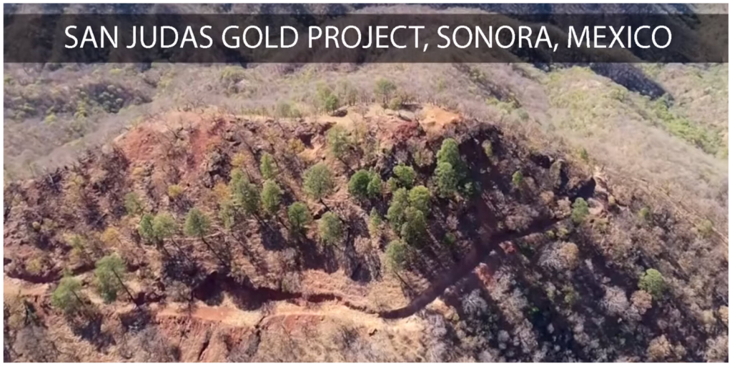
Magna Gold has fielded a team of geologists to San Judas and have been making good progress mapping and sampling the property. The company has flown key areas with a drone to produce high definition maps. Magna geologists have been mapping and sampling the many historical gold mines on the property and expanding their work to adjacent structures and parallel structures to numerous historical mining trends that are on the property. Historical workings extend over kilometers at San Judas and to date, Magna’s work has been positive.
President and CEO, Arturo Bonillas stated: “These sample results confirm our expectations for San Judas as a tier 1 exploration property. The address is right, the rocks are right, and the assays are right. We are evaluating our geologic and geochemical data to design a drill program for San Judas in 2020.”
San Judas Highlights:
Santa Lucia and La Paloma are parallel gold bearing structures approximately 500 meters apart with strong hematitic alteration between the structures. Santa Lucia is a bulk mining target and consists of a series of shallow historical mines (trenches and shafts) distributed along a line of over 900 m in length, with a 135-degree azimuth. Most of the historical mines are developed in quartz veins and veinlets hosted in a granoblastic granite showing argillic alteration within a sheared fringe; mapping has identified parallel structures on historical mines in sheared granite with quartz veinlets, oxides, and boxworks of the original sulphides (pyrite, galena, etc.). Immediately north of Santa Lucia is the Las Palomas area, where historical mines were developed on six parallel structures in granoblastic granite, dipping 45 – 50 degrees, 150-degree azimuth, sub-parallel to the Santa Lucia trend. Historical mines tend to be of low angle at depth with high angle fracturing of gray quartz cutting the main structures and foliation in the granite. The best gold values at Las Palomas site are 26.40 g/t Au producing adjacent samples of 14.60 g/t Au, 5.54 g/t Au, 7.30 g/t Au. These samples are strongly oxidized with stockwork veining containing boxworks from sulfides and strong hematite alteration.
Table 1:
Assay Results of Chip Rock Samples on Santa Lucia-Las Palomas Targets Above 0.50 g/t Au
| AREA | TYPE OF SAMPLE | LENGTH | Au g/t | Ag g/t | Pb PPM | Zn PPM | Cu PPM |
| Las Palomas | Chip Channel | 0.5 | 26.40 | 7.7 | 4803 | 95 | 31 |
| Las Palomas | Chip Channel | 1.5 | 14.60 | 4.8 | 2164 | 81 | 59 |
| Las Palomas | Chip Channel | 0.7 | 12.90 | 2.1 | 982 | 950 | 700 |
| Las Palomas | Chip Channel | 0.8 | 7.30 | 9.6 | 1865 | 80 | 23 |
| Las Palomas | Chip Channel | 1.0 | 6.14 | 6.9 | 1694 | 582 | 76 |
| Las Palomas | Chip Channel | 0.8 | 5.54 | 2.9 | 3490 | 358 | 55 |
| Las Palomas | Chip Channel | 1.0 | 4.43 | 2.2 | 1389 | 111 | 116 |
| Las Palomas | Chip Channel | 1.2 | 4.16 | 4.2 | 2256 | 84 | 16 |
| Las Palomas | Chip Channel | 0.4 | 4.08 | 1.1 | 447 | 40 | 52 |
| Santa Lucía | Chip Channel | 1.2 | 3.63 | 0.9 | 3328 | 996 | 172 |
| Las Palomas | Chip Channel | 1.2 | 2.83 | 0.5 | 829 | 48 | 27 |
| Santa Lucía | Dump | – | 2.62 | 8.4 | 9755 | 797 | 50 |
| Las Palomas | Chip Channel | 0.5 | 2.49 | 0.7 | 13 | 34 | 8 |
| Las Palomas | Chip Channel | 0.5 | 2.41 | 2.1 | 729 | 17 | 33 |
| Las Palomas | Dump | – | 2.20 | 0.9 | 323 | 390 | 51 |
| Las Palomas | Chip Channel | 1.3 | 2.01 | 43.3 | 9215 | 3518 | 164 |
| Santa Lucía | Chip Channel | 1 | 1.80 | 2.7 | 968 | 429 | 36 |
| Las Palomas | Chip Channel | 1 | 1.48 | 0.8 | 254 | 73 | 52 |
| Las Palomas | Chip Channel | 0.5 | 1.34 | 4.3 | 1389 | 964 | 45 |
| Las Palomas | Chip Channel | 1.1 | 1.22 | 6.1 | 3899 | 48 | 184 |
| Las Palomas | Chip Channel | 1.5 | 0.75 | 7.7 | 3673 | 112 | 101 |
| Las Palomas | Chip Channel | 0.5 | 0.73 | 1.3 | 888 | 16 | 536 |
| Santa Lucía | Chip Channel | 1 | 0.69 | 11.7 | 1149 | 644 | 37 |
| Santa Lucía | Chip Channel | 1 | 0.61 | 7.1 | 3008 | 868 | 39 |
| Santa Lucía | Chip Channel | 0.5 | 0.59 | 4.4 | 2115 | 2183 | 453 |
| Las Palomas | Chip Channel | 0.8 | 0.57 | 2.3 | 1824 | 47 | 177 |
- San Martin hosts gold in oxidized granite and gneiss pervasive hematite and limonite alteration. Mineralization is quartz stockwork along foliation and cross cutting quartz veinlets. San Martin has a series of historical mines oriented 155- and 180-degrees azimuth, dipping strongly to the West and East in lengths that vary from 150 to 200 meters, over an area of 1,250 m in length and 750 meters in width. Several historical workings and areas of strong hematite alteration were sampled, and assay results are shown in Table 2. The key take-away of the sampling and geological work to date in the San Martin area is the fact that the historical high-grade small mines are aligned with North-South trending structures with lower grade hematite stockwork in low-angle veining structures in the host rock, opening the possibility of finding high volume bulk deposits.
Table 2:
Assay Results of Chip Rock Samples on San Martin Area Above 0.50 g/t Au
| AREA | TYPE OF SAMPLE | LENGTH | Au g/t | Ag g/t | Pb PPM | Zn PPM | Cu PPM |
| San Martín | Chip Channel | 1.5 | 13.70 | 0.4 | 22 | 77 | 49 |
| San Martín | Chip Channel | 2 | 9.20 | 1.4 | 5 | 37 | 45 |
| San Martín | Chip Channel | 1 | 7.12 | 3.3 | 39 | 24 | 35 |
| San Martín | Chip Channel | 1 | 6.70 | 1.5 | 469 | 30 | 22 |
| San Martín | Chip Channel | 1 | 6.23 | 1.4 | 786 | 303 | 46 |
| San Martín | Chip Channel | 2 | 5.16 | 0.7 | 10 | 47 | 130 |
| San Martín | Chip Channel | 0.8 | 4.51 | 4.7 | 3285 | 133 | 407 |
| San Martin | Chip Channel | 1.9 | 4.09 | 0.5 | 20 | 59 | 241 |
| San Martin | Chip Channel | 0.7 | 3.37 | 0.4 | 201 | 223 | 202 |
| San Martín | Chip Channel | 1.2 | 3.13 | 0.7 | 44 | 31 | 81 |
| San Martin | Chip Channel | 2 | 2.84 | 2.3 | 290 | 262 | 46 |
| San Martín | Chip Channel | 1 | 2.70 | 0.4 | 152 | 20 | 168 |
| San Martín | Chip Channel | 1.2 | 2.59 | 2.7 | 1452 | 200 | 81 |
| San Martín | Chip Channel | 0.9 | 2.44 | 0.5 | 16 | 16 | 26 |
| San Martin | Chip Channel | 0.8 | 1.71 | 0.2 | 25 | 65 | 15 |
| San Martin | Chip Channel | 2 | 1.65 | 0.2 | 17 | 77 | 49 |
| San Martin | Chip Channel | 2 | 1.61 | 3.3 | 247 | 734 | 36 |
| San Martin | Chip Channel | 2 | 1.59 | 0.3 | 78 | 205 | 28 |
| San Martín | Chip Channel | 1 | 1.56 | 1.4 | 2464 | 1509 | 191 |
| San Martín | Chip Channel | 2 | 1.27 | 0.2 | 10 | 21 | 31 |
| San Martin | Chip Channel | 2 | 1.21 | 0.8 | 153 | 307 | 23 |
| San Martin | Chip Channel | 2 | 1.12 | 2.0 | 151 | 323 | 45 |
| San Martín | Chip Channel | 1.5 | 0.93 | 4.4 | 3714 | 2053 | 95 |
| San Martín | Chip Channel | 2 | 0.81 | 1.2 | 169 | 27 | 68 |
| San Martín | Chip Channel | 1.5 | 0.64 | 0.2 | 11 | 55 | 38 |
| San Martín | Chip Channel | 2 | 0.62 | 0.2 | 10 | 18 | 96 |
| San Martín | Chip Channel | 2 | 0.60 | 0.8 | 72 | 67 | 101 |
| San Martin | Chip Channel | 2 | 0.59 | 0.8 | 5 | 43 | 133 |
| San Martin | Chip Channel | 0.4 | 0.58 | 0.2 | 22 | 42 | 123 |
| San Martin | Chip Channel | 1.3 | 0.57 | 0.2 | 73 | 124 | 87 |
| San Martín | Chip Channel | 2 | 0.50 | 0.2 | 13 | 42 | 51 |
- Represo Seco is a high grade sheeted and brecciated vein system with three generations of quartz; white, crystalline quartz and chalcedony-druzy, filling open spaces in granite two meters thick with a strike length of 65 meters at the Represo Seco site and is open ended. Rock chip samples indicate a strong possibility of stacked gold structures along faults in the granite host. Magna collected a trench sample that ran 7 g/t Au at Represo Seco. Mapping and sampling are ongoing to the southwest to the property boundary with outcrops containing stockwork with hematite, jarosite, limonite, sericite alteration, clays, chlorite, bands of crackled jasperoid silica, and fine-grained magnetite disseminated in fractures. The host rock is granite. Rock samples have been collected over a strike length of several kilometers and additional assay results will be reported when received.
Table 3:
Assay Results of Chip Rock Samples on Represo Seco Area Above 0.50 g/t Au.
| AREA | TYPE OF SAMPLE | LENGTH | Au g/t | Ag g/t | Pb PPM | Zn PPM | Cu PPM |
| Represo Seco | Chip Channel | 0.5 | 7.41 | 2.8 | 226 | 142 | 153 |
| Represo Seco | Chip Channel | 1.9 | 6.03 | 2.4 | 970 | 76 | 235 |
| Represo Seco | Chip Channel | 1.8 | 5.08 | 1.7 | 576 | 65 | 209 |
| Represo Seco | Grab sample | – | 3.25 | 5.1 | 2417 | 398 | 190 |
| Represo Seco | Chip Channel | 2.3 | 2.10 | 0.7 | 1312 | 26 | 179 |
| Represo Seco | Chip Channel | 1 | 1.85 | 5.5 | 2799 | 128 | 540 |
| Represo Seco | Chip Channel | 1 | 1.52 | 4.2 | 1538 | 107 | 177 |
| Represo Seco | Chip Channel | 1 | 0.98 | 54.9 | 8102 | 60 | 1203 |
| Represo Seco | Chip Channel | 1.5 | 0.71 | 10.6 | 5299 | 79 | 1255 |
- Cueva del León hosts argillic altered intrusive felsic rocks that strike north south and dip 45-degrees generally to the west. Initial assays have been in the 1.3 to 3 g/t range. Located in the south-central portion of the property, it is an area with gold mineralization that extends in the direction of E-W, being the most notable evidence a series of historical mines occurring in a line of about 100-120 meters, the most important of which is La Cueva del Leon adit, developed along a vein of quartz and stockwork of quartz-hematite in a gneiss sequence. The mineralized area in its projection to the west is lost in the valley under the alluvial cover, towards Represo Seco as described above. It is necessary to extend the exploration in both directions of Cueva del Leon, perpendicular to the general dip of the known structure, to know its relationship with others exposed to the north and south.
Table 4:
Assay Results of Chip Rock Samples on Cueva del León Area Above 0.50 g/t Au.
| AREA | TYPE OF SAMPLE | LENGTH | Au g/t | Ag g/t | Pb PPM | Zn PPM | Cu PPM |
| Cueva de León | Chip Channel | 1.1 | 4.99 | 23.1 | 14500 | 67 | 641 |
| Cueva de León | Chip Channel | 1.0 | 4.28 | 4.5 | 2409 | 84 | 149 |
| Cueva de León | Chip Channel | 1.2 | 2.03 | 6.5 | 4233 | 40 | 294 |
| Cueva de León | Chip Channel | 1.5 | 1.90 | 23.9 | 6982 | 54 | 318 |
| Cueva de León | Chip Channel | 1.0 | 1.80 | 3.8 | 1094 | 53 | 96 |
| Cueva de León | Chip Channel | 1.2 | 1.01 | 6.4 | 2393 | 27 | 195 |
| Cueva de León | Chip Channel | 2.4 | 0.99 | 9.1 | 4238 | 79 | 50 |
| Cueva de León | Chip Channel | 1.8 | 0.83 | 2.4 | 329 | 66 | 29 |
| Cueva de León | Chip Channel | 2.0 | 0.73 | 5.5 | 3804 | 37 | 88 |
| Cueva de León | Chip Channel | 2.0 | 0.62 | 4.3 | 704 | 53 | 88 |
| Cueva de León | Chip Channel | 1.1 | 0.59 | 5.0 | 1734 | 34 | 113 |
Figure 1: Exploration targets at San Judas Property, Trincheras, Sonora.
https://www.globenewswire.com/NewsRoom/AttachmentNg/e4f9eb44-642a-416b-bdba-334648cfd2e5
San Judas Property
The San Judas project is located at the southern end of the Caborca Orogenic Gold Belt or Sonora Mojave Mega Shear, a trend known to host several orogenic gold-bearing deposits within an area extending from north-western Mexico into the southwestern United States measuring more than 600 km long and 60 to 80 km wide. Of the deposits within the Caborca Orogenic Gold Belt are a number of large open pit heap leach gold operations such as La Herradura, Soledad-Dipolos and Nochebuena (Fresnillo PLC), San Francisco mine (Alio Gold Inc), Cerro Colorado (GoldGroup Mining Inc.), El Chanate (Alamos Gold Inc) and La Choya (Hecla Mining). Historic estimates of the combined gold reserves and resources identified within the trend to date total in excess of 10 million ounces of gold (Izaguirre et al., 2017), which is based on prior data and reports obtained and prepared by previous operators.
The oldest rocks within the property are a package of metamorphic rocks which include banded quartz-feldspathic gneiss and augen gneiss, granite, and green schist. All metamorphic rocks exhibit foliation which generally varies in strike direction from between 330-degrees to North and dips to the southwest generally at 45-degrees at Santa Lucia and Cueva de Lion. The strike direction at San Martin is generally North/South with sub vertical dips. Quartz veins generally follow foliation and strike of the metamorphic rocks.
The metamorphic rocks are intruded by a Tertiary igneous package, which includes granite with visible feldspar and quartz, and is porphyritic in texture. It appears that the granite was emplaced along low angle shear zones in the system.
QA/QC Program
Quality Assurance/Quality Control consists of the regular insertion of duplicates, blanks and certified reference standards into the sample stream. Check samples will be submitted to an umpire laboratory at the end of the drilling program. Samples are kept in a secure facility and transferred to Bureau Veritas in Hermosillo, Mexico in sealed containers on a weekly basis from the drill site by Company personnel. Personnel handling samples are using Corporation-approved protocols for all phases of chip logging, sample delineation, sample layout, and storage. Bureau Veritas is ISO 9001 certified. Bureau Veritas has a standard operating procedure (“SOP”) for all aspects of sample drop off, drying and preparation, digestion, instrument analysis, quality control assurance and computerized data reporting.
Qualified Person
James Baughman, (P.Geo.) Consulting Geologist and a Qualified Person as defined by National Instrument 43-101 – Standards of Disclosure for mineral Projects, has approved the applicable contents of this news release.
About Magna Gold Corp
Magna Gold Corp is a mineral exploration company focused on acquiring, exploring and developing quality precious metals properties in Mexico. The primary strength of the Corporation is the team of highly experienced mining professionals with a proven track record of developing properties in Mexico from discovery to production.
Magna is committed to advancing its 100% owned highly prospective mineral properties located in Sonora. The Corporation’s shares trade on the TSXV under the trading symbol “MGR” and OTCQB under the trading symbol “MGLQF”.
Magna takes social license seriously and employ local community members and services in its operations.
ON BEHALF OF THE BOARD OF DIRECTORS
Arturo Bonillas
President and CEO
For further information, please contact Magna Gold Corp. +52 (662) 310 0326, email info@magnagoldcorp.com or visit our website at www.magnagoldcorp.com
THIS PRESS RELEASE DOES NOT CONSTITUTE AN OFFER TO SELL OR THE SOLICITATION OF AN OFFER TO BUY ANY SECURITIES IN ANY JURISDICTION, NOR SHALL THERE BE ANY OFFER, SALE, OR SOLICITATION OF SECURITIES IN ANY STATE IN THE UNITED STATES IN WHICH SUCH OFFER, SALE, OR SOLICITATION WOULD BE UNLAWFUL.
Cautionary Statements
Neither the TSX Venture Exchange nor its Regulation Services Provider (as that term is defined in the policies of the TSX Venture Exchange) accepts responsibility for the adequacy or accuracy of this release.
This News Release includes certain “forward-looking statements” which are not comprised of historical facts. Forward-looking statements include estimates and statements that describe the Company’s future plans, objectives or goals, including words to the effect that the Company or management expects a stated condition or result to occur. Forward-looking statements may be identified by such terms as “believes”, “anticipates”, “expects”, “estimates”, “may”, “could”, “would”, “will”, or “plan”. Since forward-looking statements are based on assumptions and address future events and conditions, by their very nature they involve inherent risks and uncertainties. Although these statements are based on information currently available to the Company, the Company provides no assurance that actual results will meet management’s expectations. Risks, uncertainties and other factors involved with forward-looking information could cause actual events, results, performance, prospects and opportunities to differ materially from those expressed or implied by such forward-looking information. Forward looking information in this news release includes, but is not limited to, the Company’s objectives, goals or future plans, statements, exploration results, potential mineralization, the estimation of mineral resources, exploration and mine development plans, timing of the commencement of operations and estimates of market conditions. Factors that could cause actual results to differ materially from such forward-looking information include, but are not limited to failure to identify mineral resources, failure to convert estimated mineral resources to reserves, the inability to complete a feasibility study which recommends a production decision, the preliminary nature of metallurgical test results, delays in obtaining or failures to obtain required governmental, environmental or other project approvals, political risks, uncertainties relating to the availability and costs of financing needed in the future, changes in equity markets, inflation, changes in exchange rates, fluctuations in commodity prices, delays in the development of projects, capital, operating and reclamation costs varying significantly from estimates and the other risks involved in the mineral exploration and development industry, and those risks set out in the Company’s public documents filed on SEDAR. Although the Company believes that the assumptions and factors used in preparing the forward-looking information in this news release are reasonable, undue reliance should not be placed on such information, which only applies as of the date of this news release, and no assurance can be given that such events will occur in the disclosed time frames or at all. The Company disclaims any intention or obligation to update or revise any forward-looking information, whether as a result of new information, future events or otherwise, other than as required by law.
